Where Wausau’s Flock cameras sit
Police Chief Matt Barnes told the Finance Committee on October 6 that “none of these are in a neighborhood,” and that the cameras are on entrances and exits to the city and on its bridges. Volunteers have mapped 20 Flock cameras in and beside the city, the same number the police department reports. Every one is on a main road, and 15 of the 20 also have a house within 300 feet. Altogether, 122 homes sit within 300 feet of a camera and 561 within 600 feet.
- 15 of 20
- mapped cameras have at least one house within 300 feet, about one block
- 10 of 20
- have five or more houses within 300 feet
- 10 of 20
- are within 1,000 feet of the city limit or a freeway ramp, or 600 feet of a river bridge
- 3 of 20
- have no home within 600 feet
How far are you from the nearest camera
Share your location or type an address, and this page measures the straight-line distance to the nearest mapped cameras.
Distances are approximate. The camera positions come from volunteer mapping, and an address lookup can be off by a house or two. The cameras photograph vehicles on the road, so living far from one doesn’t keep your car out of the database. You’re photographed each time you drive past one.
The whole city
Yellow marks residential parcels that have a house on them. Each numbered pin is a camera, and the numbers match the table below. A hollow pin is a mapped camera that hasn’t been confirmed yet. Pins that share a corner are nudged apart so both can be read.
- Camera confirmed in photos or in person
- Mapped, not confirmed
- Residential parcels with a home
- Water
- City limit
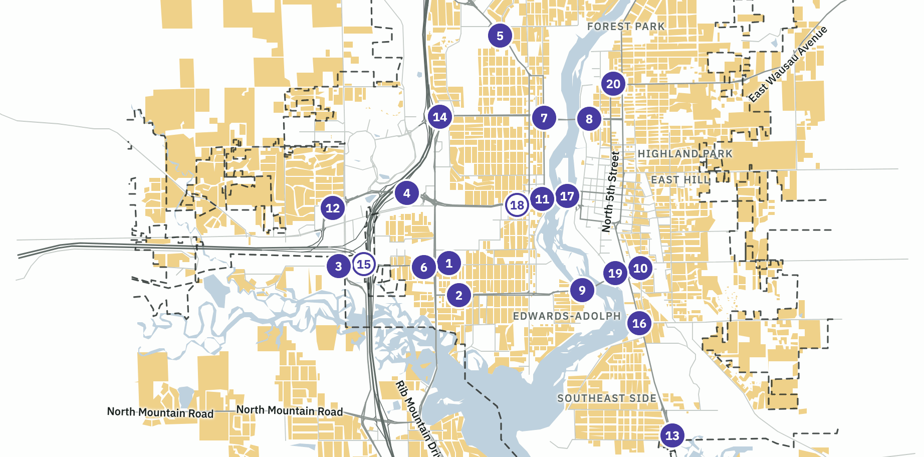
All 20 cameras
Distances are in feet, measured in a straight line from the mapped camera position to the house itself. The camera on West Thomas Street has 25 homes within 300 feet, and the nearest is 48 feet away.
| # | Road | Faces | District | Confirmed | Nearest home | Homes within 300 ft | Homes within 600 ft | Gateway |
|---|---|---|---|---|---|---|---|---|
| 1 | South 17th Avenue | northwest | 10 | 2025 photos | 235 | 1 | 23 | No |
| 2 | West Thomas Street County N | east | 10 | 2025 photos | 48 | 25 | 86 | No |
| 3 | Sherman Street | southeast | 10 | 2025 photos | Over 600 | 0 | 0 | City limit, freeway ramp |
| 4 | Highway 52 Parkway WIS 52 | southeast | 11 | 2025 photos | 914 | 0 | 0 | Freeway ramp |
| 5 | Merrill Avenue Bus. 51 | east | 8 | 2025 photos | 142 | 7 | 39 | No |
| 6 | South 17th Avenue | southeast | 10 | 2025 photos | 238 | 5 | 37 | No |
| 7 | West Bridge Street | north | 8 | 2025 photos | 95 | 7 | 32 | No |
| 8 | East Bridge Street | southwest | 5 | 2025 photos | 267 | 2 | 23 | River bridge |
| 9 | East Thomas Street County N | southwest | 3 | 2025 photos | 91 | 11 | 30 | River bridge |
| 10 | Grand Avenue Bus. 51 | northwest | 2 | 2025 photos | 164 | 9 | 45 | No |
| 11 | Stewart Avenue WIS 52 | south | 3 | 2025 photos | 363 | 0 | 13 | River bridge |
| 12 | Highway 52 Parkway WIS 52 | west | 9 | 2025 photos | 169 | 3 | 22 | Freeway ramp |
| 13 | Grand Avenue Bus. 51 | northwest | 2 | 2025 photos | 275 | 2 | 22 | City limit |
| 14 | West Bridge Street | east | 11 | 2025 photos | 156 | 3 | 7 | Freeway ramp |
| 15 | Sherman Street * | west | Stettin | Not yet | 932 | 0 | 0 | City limit, freeway ramp |
| 16 | Grand Avenue Bus. 51 | southeast | 1 | 2025 photos | 106 | 16 | 89 | No |
| 17 | South 1st Avenue Bus. 51 | north | 3 | 2025 photos | 458 | 0 | 7 | River bridge |
| 18 | Stewart Avenue WIS 52, Bus. 51 | east | 3 | Not yet | 134 | 5 | 41 | No |
| 19 | Grand Avenue County N, Bus. 51 | southeast | 1 | In person, Oct. 2026 | 74 | 10 | 39 | No |
| 20 | East Wausau Avenue WIS 52 | west | 5 | In person, Oct. 2026 | 19 | 23 | 78 | No |
* Camera 15 is about 220 feet outside the city limit, in the Town of Stettin.
Cameras by alder district
The cameras stand in 8 of the 11 aldermanic districts, and one is just over the city line in the Town of Stettin. Felix sent this breakdown to every alder on October 13. If you want to know which alder has cameras near the homes they represent, this is the list. Each alder’s totals count a home once, even when two of that alder’s cameras reach it.
| District | Alder | Cameras | Homes within 300 ft | Homes within 600 ft |
|---|---|---|---|---|
| 1 | Carol Lukens | 16, 19 | 26 | 128 |
| 2 | Michael Martens | 10, 13 | 11 | 67 |
| 3 | Terry Kilian | 9, 11, 17, 18 | 16 | 74 |
| 4 | Tom Neal | None mapped | ||
| 5 | Andrew Wiskowski | 8, 20 | 25 | 101 |
| 6 | Kristin Slonski | None mapped | ||
| 7 | Matt Hoenecke | None mapped | ||
| 8 | Sarah Watson | 5, 7 | 14 | 71 |
| 9 | Vicki Tierney | 12 | 3 | 22 |
| 10 | Lou Larson | 1, 2, 3, 6 | 30 | 124 |
| 11 | Bruce Trueblood | 4, 14 | 3 | 7 |
| Outside the city | Town of Stettin | 15 | 0 | 0 |
| All 20 cameras, each home counted once | 122 | 561 | ||
The district rows add up to 128 and 594, more than the citywide 122 and 561, because a home near cameras in two districts counts for both alders. Some cameras stand on or near a district line, so homes near them can be in the district next door. District lines are the 2026 ward boundaries from the Wisconsin Legislative Technology Services Bureau, and alder names follow the April 7, 2026 election. The full report, with a close-up map of every camera, is Flock cameras, alder by alder (PDF, 9 pages).
What the numbers mean
- A home is a parcel the assessor classes as residential that has a building on it, taken from the 2026 statewide parcel database. Distance runs from the mapped camera point to the largest building on that parcel, using Microsoft building footprints. Condominium units are measured to the unit.
- Wisconsin assesses apartment buildings of four or more units as commercial, so those aren’t counted and the totals run low, most of all near downtown.
- A gateway is a camera within 1,000 feet of the city limit, within 1,000 feet of a freeway ramp, or within 600 feet of a bridge over the Wisconsin River. These thresholds are this page’s own. Stretching all three to a quarter mile raises the count for all 20 mapped cameras from 10 to 14.
- The citywide totals count each home once. A home within 300 feet of two cameras is counted one time.
- “Neighborhood” has no fixed definition, and the chief didn’t give one. The same camera can sit on a state highway and have houses on both sides of it.
Where to be careful
- Camera positions come from volunteer mapping on OpenStreetMap, not from the police department. 16 of them can be seen on their poles in Google Street View photos from mid-2025, within a few feet of the mapped point.
- Cameras 19 and 20 were added to the map after those photos were taken. Volunteers found both on their poles in person in October 2026.
- The other 2 (cameras 15 and 18) were also added after the photos, and volunteers haven’t confirmed them yet.
- 13 of the 20 are tagged as operated by Wausau police, all by one mapper in January 2025 who cited local knowledge. The other 7 record no operator. None sits at any of the eight state-highway permit sites held by the Marathon County Sheriff, but nothing here proves who runs them.
- The department has said its 20 cameras stand at 11 locations, 18 on existing utility poles and 2 on Flock’s own poles, and were installed from February to July 2023. It released its list to the Wausau Pilot & Review but hasn’t published it. The 20 points here fall at about 15 separate sites, so this isn’t the same list. The department’s list is the authority.
- Camera 13 is 190 feet inside the city limit, and its nearest houses are across the line in Schofield.
- Near camera 16, 32 of the homes within 600 feet are units in one condominium complex.
Camera points: OpenStreetMap surveillance nodes. Streets and water © OpenStreetMap contributors (ODbL). Parcels and property class: Wisconsin Statewide Parcel Map, version 12 (2026). Building footprints: Microsoft, via Esri. City limit distances: U.S. Census Bureau TIGER, 2026. District lines: Wisconsin Legislative Technology Services Bureau, 2026. Street-level photos were viewed in Google Street View and aren’t reproduced. No owner names or addresses are used. The chief’s statement is at 45:53 in the video of the October 6 Finance Committee session.